Women fisherfolk voice out the devastating impact of the industrial seaport expansion at Map Ta Phut on their livelihood

Women play a vital role in small-boat fishing. Their role extends beyond catching fish, as they also contribute to the sustainability of fishing practices. However, the rapid industrial development along the shoreline of Map Ta Phut in Rayong Province, Thailand, is threatening the local fishing community by destroying marine habitats, leading to a loss of livelihood for many women fisherfolk.
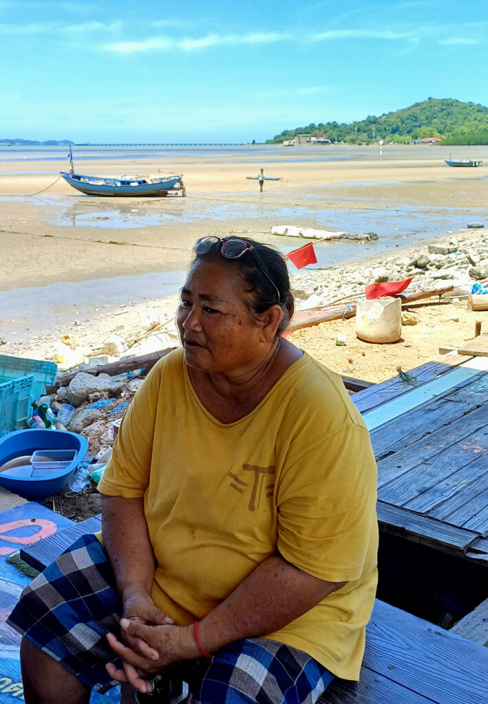
Pu, who has been fishing for 20 years, reminisced about her earlier life when fish and other marine resources were abundant.
“During that time, my husband and I used to go out with our small boat and could catch up to 100 kilograms of fish, squids, and shells. Fishing was profitable, and we were able to earn up to 6,000 baht ($164) per day,” Pu explained.
But now, Pu is helpless as land reclamation on Map Ta Phut’s shoreline has impacted small-boat fishing over the years, slowly washing away their livelihood.
“I hardly go out to the sea to catch fish nowadays because there is nothing there. I spent about eight hours and only managed to catch two kilograms of fish and squids. After I sell my catch, I would earn 300 baht ($8) per day,” she said.
Similar to Pu, the women fisherfolk from the nearby village of Laem Rung Ruang have experienced a decline in fish catches in recent years. As a result, Mei, who used to fish in the past, was left with no choice but to switch to other work to earn a living.
“Small-boat fishing is collapsing. I switched to fixing fishing nets and selling drinks instead,” informed Mei.
Land reclamation on the shoreline
Land reclamation at Map Ta Phut’s shoreline, driven by the expansion of the industrial seaport, has been ongoing for several years. This project threatens the livelihood of the local fishing community as it encroaches upon their once-abundant fishing grounds. In addition, the construction activities on the shoreline disrupt the delicate balance of the marine ecosystem, leading to a loss of biodiversity and reduced catches.
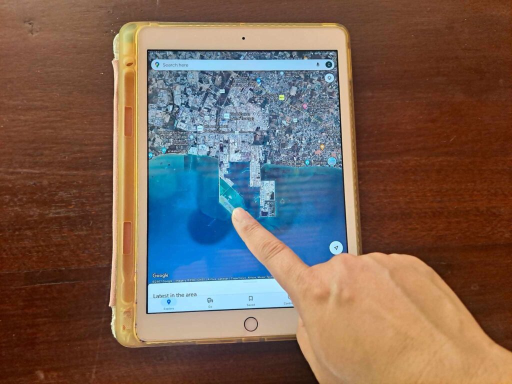
Rangsan from Pak Nam village, pointing at the map of the area that used to be a fishing ground but is now filled with land, said: “Our fishing ground has shrunk. To me, the land reclamation seems to be the main cause of the reduction in fish catch.”
“Now, it is more difficult to fish. Small-boat fisherfolk need to go five kilometers farther out to sea, and there is a risk of getting hit by the large ships and barges,” she added.
The information on the industrial seaport’s expansion was sourced from here
Map Ta Phut Industrial Port
The Map Ta Phut Industrial Port covers a land area of 2,870 rai (1,134 acres) and is recognized as the largest seaport in Thailand. It was completed in 1992 and further expanded in 1999 to accommodate the increased demand for industrial shipping services in the country.
In 2019, the Industrial Estate Authority of Thailand approved the third expansion project for the industrial seaport, aiming to double the facility’s capacity for transporting Liquified Natural Gas (LNG) and liquid raw materials for the country’s petrochemical industry. The project is valued at 55.4 billion baht ($1.5 billion) and will involve the construction of new LNG terminals, berths, storage tanks, and warehouses on 1,000 rai (395 acres) of reclaimed land from the sea. Once completed, the industrial seaport is expected to transport 31 million tons of natural gas and liquid raw materials annually for the next 30 years, nearly twice its current capacity of 16 million per year.
MAP TA PHUT INDUSTRIAL PORT PHASE 3 PROJECT
- Location: Rayong, Thailand
- Purpose: Increase the transport of LNG and liquid raw materials for petrochemical industry in Thailand
- Cost: 55.4 billion baht ($1.5 billion)
- Area: 1,000 rai (359 acres) of land reclaimed from the sea
- Facilities: LNG terminals, berths, storage tanks, and warehouses
- Start: 2019
- Status: Construction ongoing
- Information sources: Map Ta Phut Industrial Port, Eastern Economic Corridor
Industrial pollution and fatal accidents
The industrial seaport is located within Map Ta Phut Industrial Estate, which was established in 1989, a few years before the seaport was built. In addition to the seaport, the industrial estate is the home to nearly 60 other large facilities, including petrochemical plants, oil refineries, coal-fired power stations, and steel factories. As the largest in Thailand, investors have promoted the Map Ta Phut Industrial Estate as a model for large-scale development projects for the past three decades. However, the industrial estate casts a negative shadow over the local communities near the area.
The industrial estate is infamous for being a significant source of air pollution, water contamination, hazardous waste, and fatal accidents that have resulted in injuries and loss of life. Over the years, numerous news reports have highlighted the unhealthy conditions prevailing in the area.
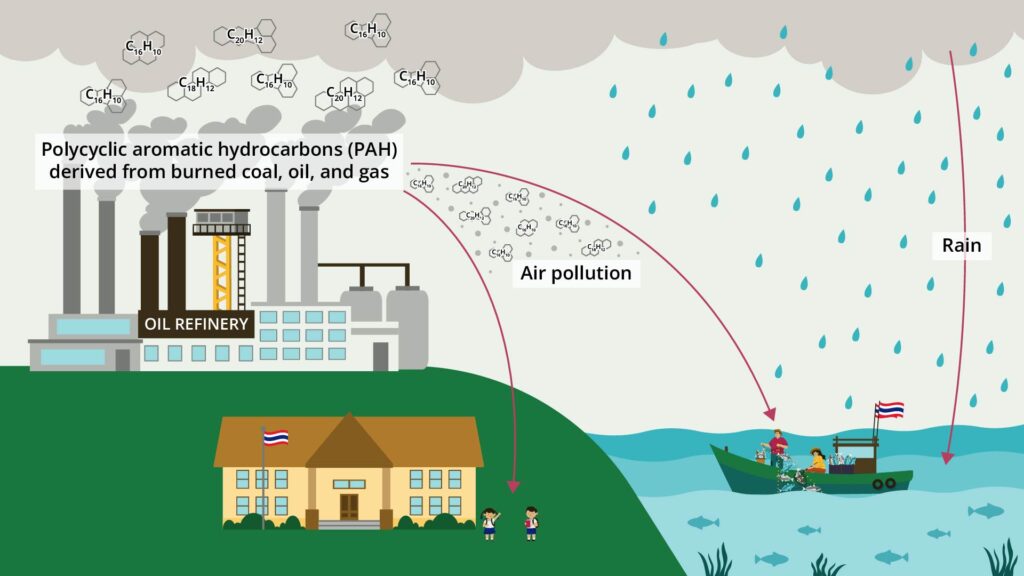
In 1997, the industrial estate made headlines when a nearby school was compelled to shut down and temporarily transfer its students and teachers to other schools. This drastic measure was taken after the school’s students and teachers fell ill due to exposure to toxic air. They suffered from various symptoms, including headache, vomiting, and chest pain. Some cases were so severe that the affected individuals were admitted to hospitals.
When coal, oil, and gas are burned, they release pollutants into the atmosphere, including polycyclic aromatic hydrocarbons (PAHs). These pollutants enter the human body through breathing and food consumption. Once inside the body, they can bind with a person’s DNA and form adducts. If these DNA adducts are not repaired, they can lead to mutations, which can result in the development of cancerous cells.
A decade after the 1997 incident, a scientific research was conducted to compare the levels of bulky DNA adducts in people living near the Map Ta Phut Industrial Estate with those in the rural communities in Rayong Province. It was found that those living near the industrial estate had nearly 65% higher levels of bulky DNA adducts compared to those in the rural area.

Environmental protection and fair compensation
Despite the threat to local communities, the Map Ta Phut Industrial Estate and the seaport’s expansion project continue. In this case, it is clear that the universal human right to a healthy and sustainable environment, which the United Nations adopted in 2022, is violated. For the women fisherfolk like Pu, Mei, and Rangsan, whose livelihoods are currently impacted by land reclamation on Map Ta Phut’s shoreline, the end to their struggle is still far from being over.
“I try to adapt to the new way of life without fishing for a long time. Land reclamation and other industrial projects are taking place around me, and they are happening very quickly,” said woman fisherfolk Lak.

The story of the women fisherfolk is one of resilience. They stand up and fight for their rights and livelihood, exemplifying the strength and determination needed to overcome the challenges posed by industrial development. Their adaptability in the face of adversity is remarkable, and they are not giving up on hope for a future where environmental protection and fair compensation are not just ideals but a reality.
EarthRights is directly collaborating with the women fisherfolk to collect data and document the impact of the industrial port expansion project at Map Ta Phut. Using evidence-based research led by the local communities, they are better equipped to demand environmental protection and fair compensation, especially for their livelihood losses.


