“We now realize and understand the value of our resources which we were never aware of before.” -Thet Ye Winn, member of Kalubar Village Development Organization
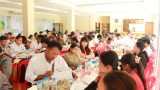
The report launch was attended by nearly one hundred people including government officials, civil society leaders, and villagers from the KyaukPhyu Special Economic Zone area. It was hosted by EarthRights International (ERI), in partnership with Oxfam, the Center for Environment and Resource Development in Arakan (CERDA) in Kyauk Phyu township, in late January. The report, Community Natural Resource Mapping, is the result of ten months of participatory action research in four villages in Kyauk Phyu, Rakhine (Arakan) State in Myanmar.
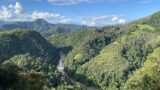
The research was conducted in Kalubar, Chaung Phyar, Sittaw and Shauk Chaung villages in the Kyauk Phyu Special Economic Zone from March to December 2016, with the aim of giving communities a deeper understanding of their relations with and reliance on their natural resources. The process started with a 12 days long training on community-led natural resource mapping that facilitated community members to research and physically map their villages and natural resources and identify how their livelihoods rely on those natural resources. In turn, they can then improve their community-driven natural resource management and governance. To get a full picture of the relationship between the villagers and the natural resources on their land we had to evaluate many aspects. The villagers chose 13 topics[1] including village history, socio-economy, natural resources, forest and non-timber forest products. Eleven participatory rural appraisal (PRA) tools[2] were used, including a resource mapping, histograms, transect walk, seasonal calendar, forest inventory, daily timeline on gender, gender analysis on care activities (an analysis of how much men and women of different ages spend their time for unpaid care activities) were used. These tools are used to recognize the value of popular collective knowledge and wisdom and legitimize the production of knowledge by the people themselves, seek to be catalysts enabling and empowering the people.
“Through the process, I found that the communities became more aware of the value of natural resources and the relationship and collaboration among villagers improved. Moreover, we published a strong report, which covered natural resources and socio economic issues, and can be used for our future advocacy,” said Soe Shwe, a manager from CERDA.
 State in Myanmar.")
The community natural resource mapping process highlights the value of collective local wisdom and knowledge and legitimizes the production of knowledge by local people themselves. This encourages public participation in resource management and increases the capacity of community leaders so they can respond better to the needs of the community, and enhances the community’s understanding of the value of its natural resources.
“This is a first for community-driven natural resource management. Our effort to document our resources will never end and our vision that ‘We will manage our own resources’ will come true,” a villager from ChaungPhyar said.
[1]1)location and area, 2)village history, 3)socio-economy ,4)natural resource ,5)water resource, 6)forest products, 7)non-timber forest products, 8)tradition and culture,9)education,10)health,11)community base organizations ,12)electricity ,13)transportation
[2]1) resource map, 2) village map, 3) transect walk, 4) seasonal calendar, 5)histogram, 6) forest inventory, 7)daily timeline of men and women, 8) list of terrestrial animals and aquatic creatures,, 9) list of forest products and non-timber forest products 10) gender analysis on care activities 11)households questionnaires